
2022 Atlantic, Caribbean & Gulf Of Mexico Hurricane Season Forecast (Issued March 9)
Bullseye Adjusting's official weather resources is Crown Weather. This article they recently released about the 2022 storm season has us anticipating lots of opportunity for working claims this year! Read Below.
By Crown Weather Services
Wednesday Afternoon, March 9, 2022
Summary: I am forecasting yet another above average tropical storm and hurricane season. The reason for this is due to the potential for a third consecutive year with La Nina conditions, the forecast of above average ocean water temperatures and the possibility of widespread average to slightly lower than average wind shear conditions.
With that said, there is some uncertainty with exactly how active things may be. The reason why is because there aren’t too many cases in history that have a third consecutive year with La Nina conditions. Those that do (which include 1894, 1910, 1917, 1956, 1975, 1985 and 2000) ended up overall with near average or below average activity.
The Numbers: 16 Named Storms, 9 of those storms becoming Hurricanes and 3 of those hurricanes becoming Major Hurricanes (Category 3 or higher on the Saffir-Simpson scale).
Accumulated Cyclone Energy (ACE) Index Forecast: I am forecasting an ACE index this year of 135. This number basically says that I expect that overall activity in the Atlantic will be about 40 percent above the 1951 to 2020 average amount of activity.
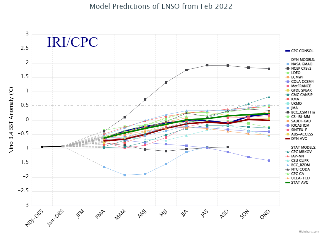
ENSO Conditions: Weak La Nina conditions currently exist across the Pacific and current ENSO guidance forecasts that we should “warm” to neutral ENSO conditions by early this summer. Much of the ENSO guidance then forecast that ENSO conditions will remain neutral throughout this summer into this autumn. This is extremely similar to what occurred during the 2021 Hurricane Season.
Should this occur during the 2022 Atlantic Hurricane Season, it would potentially mean that ENSO conditions would be favorable for yet another active season.
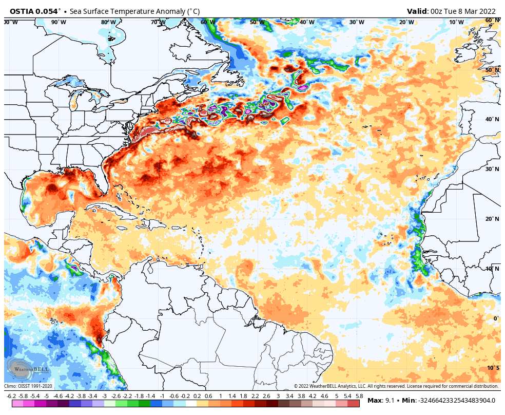
Sea Surface Temperatures: Sea surface temperatures across the Atlantic Basin look very similar to what they looked like at this time last year. In fact, the sea surface temperatures across the Atlantic Basin also look very similar right now to what it looked like at this time in 2020.
Across the Western Atlantic, the Gulf of Mexico and the Caribbean (west of 55 West Longitude) ocean water temperatures are warmer than average. Across the central and eastern Tropical Atlantic, sea surface temperatures are below average.
One of the keys in determining how active/inactive the hurricane season will be is how much will the deep tropics (south of 25 North Latitude) warms up during April, May and June. It should be noted that at this time in 2017, 2018, 2019, 2020 and 2021, the Atlantic Main Development Region was running a little below average in sea surface temperatures, but this pattern reversed during the hurricane season leading to a much more active season than what was originally thought.
I think that it is likely that the deep tropics will seeing above average ocean water temperatures, much like what we have seen during the last several hurricane seasons, during July, August and September. In addition, it looks like the Western African Monsoon will be active this year leading to the development of some strong tropical waves moving off of Africa.
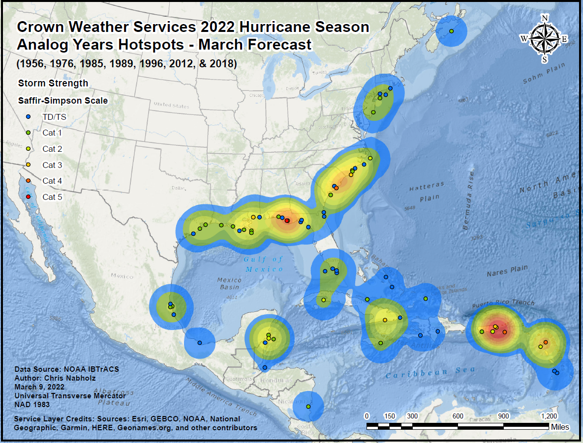
Analog Years: These are the analog years that seem to be a close match right now to what the 2022 hurricane season may be like. They are 1956, 1976, 1985, 1989, 1996, 2012 & 2018.
Based on what I am seeing comparing the current weather pattern to the analog years I have listed, I am putting special emphasis on 1989, 2012 and 2018 as analog years for this season. This means that the Southeast US Coast and the US Mid-Atlantic Coast could be at particular risk this season for a landfalling tropical storm or hurricane. Other areas that may be at particular risk are the northern US Gulf Coast and the Leeward Islands and the Virgin Islands. More on that in my landfall threat forecast.
This is our “hot spot” map which shows which areas were impacted the most during the 7 analog years I have listed:
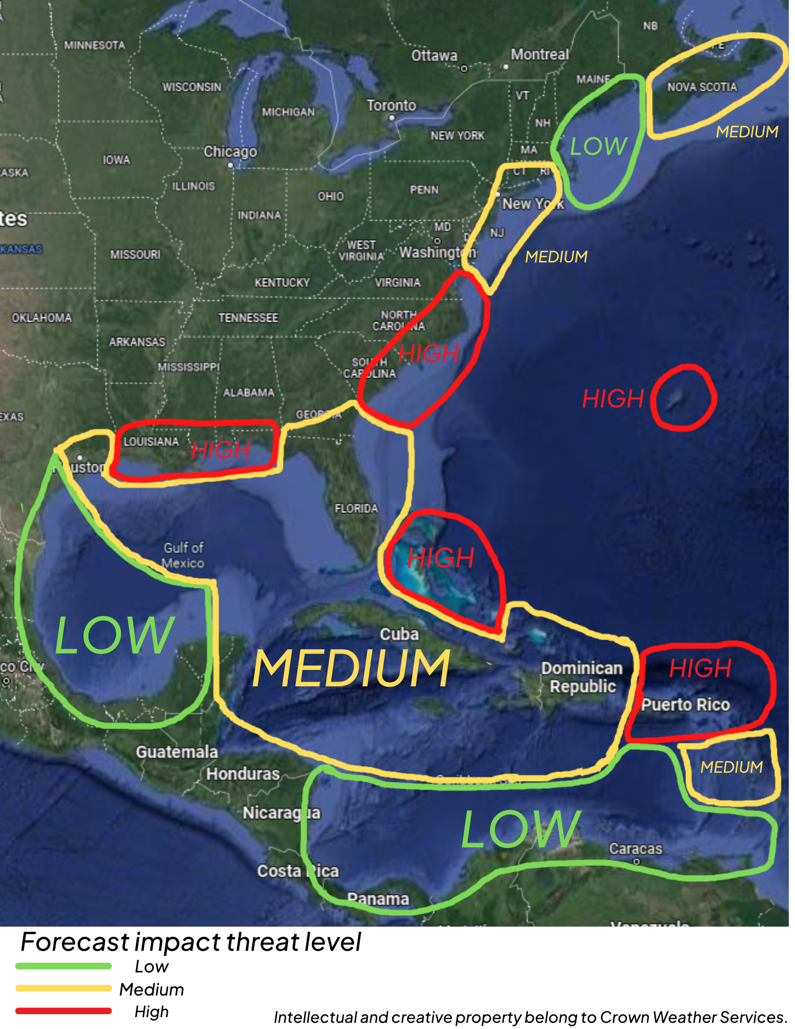
Weather Pattern Forecast: Current seasonal guidance are pointing towards the possibility that a persistent upper level trough may set up right along the US East Coast and may remain in place during much of the hurricane season.
What longitude the trough axis sets up is going to be extremely important in determining whether any westbound tropical systems are turned northward well offshore of the US Coastline or if they are turned in a way so that there is a tropical threat along the US East Coast.
This trough will also be important because any tropical systems that push into the Caribbean could be turned northward towards the US Gulf Coast rather than heading westward towards eastern and southern Mexico.
Landfall Threat Forecast: There are about three areas that I’m most concerned about for this upcoming season in terms of a tropical storm or hurricane impact.
The First Area Is the Leeward Islands, Virgin Islands and Puerto Rico. Both the analog data and the seasonal guidance such as the NMME, CFS and European seasonal guidance are showing signals that this is going to be a spot to really keep an eye on.
The Second Area Of Particular Concern Is a corridor from the northern Bahamas and southeast Florida through South and North Carolina to the Mid-Atlantic coast and Southern New England. Analog data points to that tropical storm/hurricane activity could be steered in this direction. These indications are supported by all of the seasonal guidance.
The Third Area Of Concern Is the Northern US Gulf Coast from Louisiana to the Florida Panhandle. With the possibility of an East Coast mean trough, it could lead to any systems pushing across the Caribbean to be steered northward towards the US Gulf Coast.
Even though your area may have a low or medium risk this season, be aware that any small fluctuations in the upper level weather pattern at the “wrong” time could threaten the low or medium risk areas.
Finally, we will begin sending out daily tropical weather discussions for the 2022 Atlantic Hurricane Season on Sunday, May 1st.
2022 Atlantic Tropical Cyclone Names:
Alex
Bonnie
Colin
Danielle
Earl
Fiona
Gaston
Hermine
Ian
Julia
Karl
Lisa
Martin
Nicole
Owen
Paula
Richard
Shary
Tobias
Virginie
Walter
If you have questions regarding this discussion, do not hesitate to contact crownweather@gmail.com.
Disclaimer: All forecasts herein are made to the best ability of the forecaster. However, due to standard forecasting error, these forecasts cannot be guaranteed. Any action or inaction taken by users of this forecast is the sole responsibility of that user.